Hydrogeophysics
We provide precise and detailed insight into subsurface conditions by applying a wide range of hydrogeophysical methods, technologies, and concepts.
Sustainable water supply strategies require detailed insight into subsurface conditions. While drilling provides vertical 1D or 2D information about soil layers at highly specific locations, geophysical methods enable full 3D mapping of the subsurface between boreholes.
By applying hydrogeophysics, we deliver the comprehensive knowledge required for strategic water resources management – including groundwater aquifer mapping and assessment of saltwater intrusion risks. We utilise a wide range of innovative hydrogeophysical methods, such as:
tTEM: Efficient 3D mapping on land
The tTEM-system is a quadbike-towed, transient electromagnetic system, designed for detailed 3D hydrogeological mapping to a depth of 80-130 m in a fast and cost-efficient way. The detailed 3D coverage is obtained by fast data repetition and a small line spacing of typically 25-50 m.
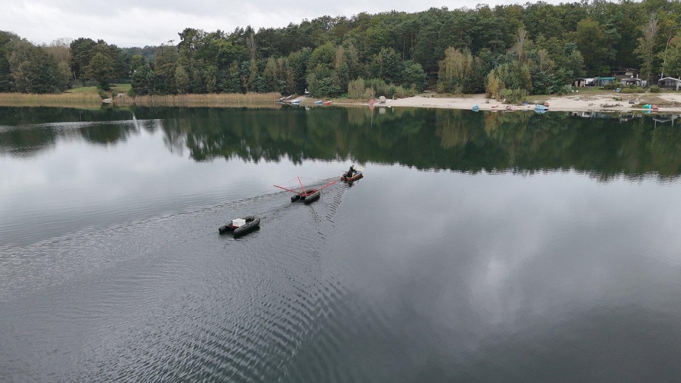
FloaTEM: Efficient 3D mapping on water bodies
FloaTEM is a transient electromagnetic method for data acquisition on water and is a further development of the land based tTEM system but with the system towed behind a boat. With dense survey lines a 3D coverage is obtained down to a depth of ~70-120 m. The method is ideal for both hydrogeological and geotechnical mapping on water, where boreholes are expensive and scarce.
sTEM: A flexible and ultra-portable solution
The sTEM system is an ultra-portable, compact system and lightweight carried by foot, making it ideal for areas that are normally not accessible by, e.g., quadbike. The system offers fast measurements and comes in both a profiler version, where multiple soundings to a depth of up to ~200 m can be made per day, as well as a larger loop version for even greater penetration depth.
SkyTEM: High-resolution deep sub-surface mapping
SkyTEM delivers market-leading sub-surface mapping from 1 to 800 meters in depth, optimised for groundwater management and mineral exploration. The SkyTEM Diamond system offers exceptionally near-surface exploration, covering depths from 1 to 200 meters, making it ideal for geotechnical, engineering, and environmental applications. All SkyTEM airborne systems operate in all-terrains with helicopters and drones, ensuring efficient and reliable data acquisition.
DualEM: High resolution near surface mapping
The DualEM provides a quadbike based towed, electromagnetic system with unmatched resolution in the upper 5-8 meters. Its high acquisition speed enables detailed 3D mapping that can provide essential data regarding, e.g., geotechnics, soil contamination, water infiltration/retention, and soil resistivity.
ERT: A proven method for identifying sub-surface water sources
The Electrical Resistivity Tomography technique (ERT) is a well-known geophysical method operated by two people on foot. The method is very robust when it comes to cultural noise, e.g. power lines, and the acquisition method enables usage in areas where other methods cannot be applied. Typical applications include geotechnics, soil resistivity (earthing/grounding), soil contamination, and natural resources.
RELATED INSIGHTS
To the last drop: Why we need sustainable groundwater management
Water management
This year, for UN World Water Day, we celebrate groundwater. Modern life as we know it would simply not be possible without this precious resource. It’s worth reminding ourselves about the importance of managing groundwater in the most sustainable way possible.
RELATED INSIGHTS
RELATED PROJECTS
AEM mapping California’s groundwater

Project
USA
Tackling South Africa's Day Zero crisis
Project
South Africa
Contact Ramboll in the Asia Pacific region
Ramboll is widely represented in the Asia-Pacific region with several offices distributed across Australia, Hong Kong, India, Japan, Malaysia, Singapore, South Korea, and the United Arab Emirates.
Find your local office in the APACContact our experts
Joakim Hollenbo Westergaard
Senior Consultant, geophysics
Water
Nils Bischoff
Chief Engineer
Buildings
Environmental and nature-based services
Our multidisciplinary platform of environmental services helps clients address environmental impacts of some of the toughest global problems: urbanisation, climate change, water management, and resource scarcity.
Water resources management
Helping meet increased water demands around the world for communities, industries, and irrigation.
Water
Creating value for clients and societies by converting water- and climate-related challenges into opportunities.